LSWA Projects
Status: 100% Complete
Project Manager: Dick Norlin
A lot has changed since our last Lake Management Plan was developed in 1995. New invasive species have been introduced in our lake (Eurasion Milfoil and Fanwort) as well as new methods of weed treatment like CLIPPER and DASH (Diver Assisted Suction Harvesting). The surrounding watershed area has also changed in many ways like new home construction, Millbury town sewer, and the Stockwell ponds and the Merrill pond dam removal.
In order to better understand the condition of our lake (Trophic State) as well as document a plan to monitor, manage, and control water levels, weeds/invasive species, and algae, LSWA in partnership with Geosyntec has developed a new lake management plan to better manage Lake Singletary and its watershed.
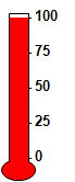
Lake Singletary is in much better condition than we had originally thought due to new technology and more accurate methods to measure lake conditions. The standard gauge to measure the condition of a lake is called Trophic State. The trophic state method has 4 classifications (Oligotrophic, Mesotrophic, Eutrophic, and Hypereutrophic). You will be happy to know that Lake Singletary is currently classified as a lower mesotrophic lake, which is a really good thing. Our lake has a TSI (trophic state index) rating of 41!
In the Lake Management Plan you will find the follow topics that are crucial to a successful Lake Management Plan as well as a link to the entire lake management plan document.
- Trophic State Assessment
- Lake Singletary Phosphorus Budget
- Phosphorus Concentration Modeling
- Watershed Management Recommendations
- Dam Removal at Stockwell Ponds
- Regulatory and Land Planning Tools
- Aquatic Vegetation and Algae Management
- Field Guide to the Aquatic Plants of Lake Singletary
- Watershed Maps and Figures
- Watershed Soils Map
- Watershed Impervious Surfaces
- Watershed Land Uses
- CMRPC Estimation of Developable Land, Southeast Subregion
- Proposed Constructed Wetland BMP, Crestview Lane
- Proposed BMP Locations
- Analysis of Historic Dissolved Oxygen Profiles
- Watershed Topographic Map and Water Quality Sampling Locations